
Vision Zero Chapel Hill

Whether you're driving, walking, or cycling, your input is important.
“Vision Zero Chapel Hill” is a local initiative to eliminate traffic deaths and serious injuries by 2031. Through traffic safety solutions and equitable mobility options for all, Vision Zero uses strategies informed by data to increase road safety to prevent serious injury and decrease crashes. These are the three main pillars of Vision Zero in Chapel Hill:
- Guiding town-wide policies for transportation planning, the design of streets and sidewalks, the maintenance of public rights-of-way, and traffic enforcement;
- Working with the community to create “Safe Routes to School”; and
- Prioritizing the safety of all road users in transportation decisions, with a special emphasis on vulnerable road users.
For additional information and data, the Town has created a Vision Zero Dashboard that shows bicycle and pedestrian-involved crashes between 2007-2024. Availability of data varies by year. Crashes include UNC Police and CHPD reports. Bicycle data begins in 2019.
-
Skipper Bowles Drive Walk Audit 1/12/26
Share Skipper Bowles Drive Walk Audit 1/12/26 on Facebook Share Skipper Bowles Drive Walk Audit 1/12/26 on Twitter Share Skipper Bowles Drive Walk Audit 1/12/26 on Linkedin Email Skipper Bowles Drive Walk Audit 1/12/26 link
The Vision Zero team invites you to join our walk audit on Monday January 12th from 9:00 AM-10:00 AM. The audit route will be around one mile, along Skipper Bowles Dr. Our central meeting location will be the Ridge Rd and Manning Dr intersection. A walk audit allows us to assess the conditions of the street, identify safety concerns, and develop potential improvement in this area.
If you would like to send this email out to your neighbors and community members, please use this link! Thank you very much and we hope to see you there!
Who: Anyone interested in Vision Zero, pedestrian safety, and safer streets
What: Skipper Bowles Walk Audit
When: Monday January 12th from 9:00 AM-10:00 AM
Where: Intersection of Ridge Rd and Manning Dr
Why: We will assess current conditions, identify safety concerns, and develop potential improvements in this area.
Getting there:
- Parking:
- Williamson Lot (Paid Parking)
- Rams Head Parking Deck (Paid Parking)
-
Closest bus stops:
- Bowles Drive at Craige Dorm (RU)
- Manning Drive at Hinton James (U)
- Ridge Road at Ehringhaus Hall (CCX and RU)
What to expect:
- If you have never done one, the purpose of a walk audit is to gather on-the-ground knowledge of safety concerns cyclists and pedestrians face so that we can find potential improvements.
- We will have safety vests, worksheets, clipboards, and pens for all participants.
- We expect the total distance covered will about 1 mile of total walking (see map attached).
Please take a virtual walk in Google Street view prior to meeting.
-
Legion Road Walk Audit 11/17
Share Legion Road Walk Audit 11/17 on Facebook Share Legion Road Walk Audit 11/17 on Twitter Share Legion Road Walk Audit 11/17 on Linkedin Email Legion Road Walk Audit 11/17 link The Vision Zero team invites you to join our walk audit on Monday November 17th from 3:30 PM-4:30 PM. The audit route will be around a mile from Formosa Lane to Cooper Street along Legion Rd. Our central meeting location will be the Formosa Ln. and Legion Rd. Intersection
A walk audit allows us to assess the conditions of the street, identify safety concerns, and develop potential improvement in this area. If you would like to send this out to your neighbors and community members, please use this link! Thank you very much and I hope to see you there!
Who: Anyone interested in Vision Zero, pedestrian safety, and safer streets
What: Legion Walk Audit
When: Monday November 17th from 3:30 PM-4:30 PM
Where: Intersection of Formosa Ln. and Legion Rd.
Why: We will assess current conditions, identify safety concerns, and develop potential improvements in this area.
Getting there:
Parking:
Village Office Park
Closest bus stops:
Legion Road at Formosa Drive (Bus Route D)
What to expect:
If you have never done one, the purpose of a walk audit is to gather on-the-ground knowledge of safety concerns cyclists and pedestrians face so that we can find potential improvements.
We will have safety vests, worksheets, clipboards, and pens for all participants.
We expect the total distance covered will about 1 mile of total walking (see map attached).
Please take a virtual walk in Google Street view prior to meeting.
-
UNC Walk Audit RAIN DATE: Tuesday 9/30
Share UNC Walk Audit RAIN DATE: Tuesday 9/30 on Facebook Share UNC Walk Audit RAIN DATE: Tuesday 9/30 on Twitter Share UNC Walk Audit RAIN DATE: Tuesday 9/30 on Linkedin Email UNC Walk Audit RAIN DATE: Tuesday 9/30 link
Due to today's weather, we are postponing our walk audit to Tuesday, September 30th from 2:30 PM-3:30 PM. The audit route will be one mile, forming a loop from Country Club Rd., South Rd., Raleigh St. and back to our starting point:

Our central meeting location will be the Country Club Rd. and Raleigh St. intersection:
 A walk audit allows us to assess the conditions of the street, identify safety concerns, and develop potential improvement in this area!
Who: Anyone interested in Vision Zero, pedestrian safety, and safer streets
What: UNC Walk Audit (Loop from Country Club, Raleigh Rd, and Raleigh St.)
When: Tuesday, September 30th from 2:30 PM-3:30 PM
Where: Intersection of Country Club Rd and Raleigh St.
Why: We will assess current conditions, identify safety concerns, and develop potential improvements in this area.
Event Link: Vision Zero Chapel Hill | Engage Chapel Hill
Getting there:
- Parking:
- Parking: Morehead Lot (Paid Parking)
- East Rosemary Deck (Paid Parking)
- Closest bus stops:
- Raleigh Street at Spencer Hall (NU, U)
- Raleigh Street at Mangum Hall (NU, U)
What to expect:
- If you have never done one, the purpose of a walk audit is to gather on-the-ground knowledge of safety concerns cyclists and pedestrians face so that we can find potential improvements.
- We will have safety vests, worksheets, clipboards, and pens for all participants.
- We expect the total distance covered will about 1 mile of total walking (see map above).
Please take a virtual walk in Google Street view prior to meeting.
- Parking:
-
Office of Mobility & Greenways Open House
Share Office of Mobility & Greenways Open House on Facebook Share Office of Mobility & Greenways Open House on Twitter Share Office of Mobility & Greenways Open House on Linkedin Email Office of Mobility & Greenways Open House link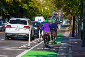
Come learn about current and upcoming Town of Chapel Hill Transportation and Mobility projects.
When: Thursday, September 11 from 6 - 7:30 p.m.
Where: Chapel Hill Public Library, Room A
We’ll share information about these current and upcoming projects:
- N. Estes Dr. resurfacing & bike lanes (Caswell Rd. to E. Franklin St.)
- Pinehurst Dr. resurfacing & bike lanes (Burning Tree Dr. to Ephesus Church Rd.)
- Ephesus Church Rd. sidewalks
- Fordham sidepath
- Vision Zero
- Safe Routes to School
- Everywhere to Everywhere Greenways Feasibility Study
-
New Traffic Calming Effort on S. Elliott Rd.
Share New Traffic Calming Effort on S. Elliott Rd. on Facebook Share New Traffic Calming Effort on S. Elliott Rd. on Twitter Share New Traffic Calming Effort on S. Elliott Rd. on Linkedin Email New Traffic Calming Effort on S. Elliott Rd. link
Next time you travel on S. Elliott Road you’ll notice new modular medians designed to slow cars down. Our Public Works staff placed the medians at a curve in the road just west of Fordham Boulevard. These medians help calm traffic by requiring drivers to slow down to stay in their lane as the road curves.

-
Safety Improvements on Martin Luther King Jr. Blvd.
Share Safety Improvements on Martin Luther King Jr. Blvd. on Facebook Share Safety Improvements on Martin Luther King Jr. Blvd. on Twitter Share Safety Improvements on Martin Luther King Jr. Blvd. on Linkedin Email Safety Improvements on Martin Luther King Jr. Blvd. link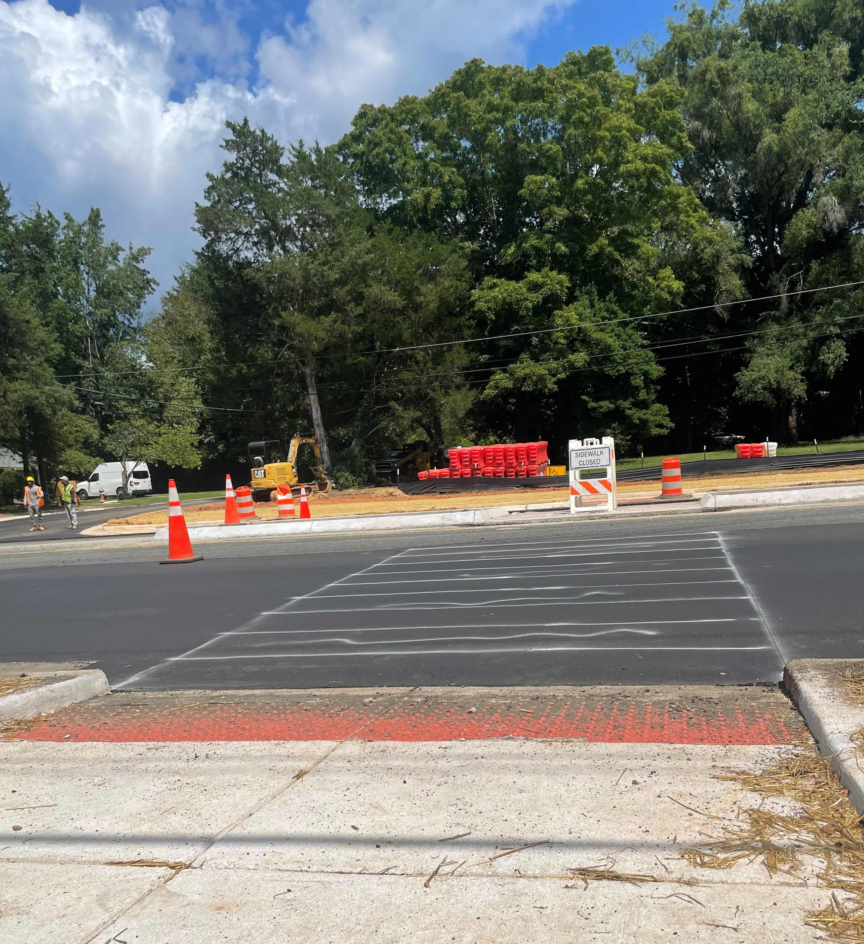
A new crosswalk is under construction on Martin Luther King Jr. Boulevard between Taylor Street and Critz Drive. This crossing is similar to others along the road – it’ll have flashing lights to alert drivers and a pedestrian island where people can stop to make sure the road is clear. We’re also adding a sidewalk on the east side of the road, filling an existing gap for people who are walking along the road.
The NC Department of Transportation tested multiple locations for this crosswalk and ultimately settled on this as the best choice for overall function and safety of everyone using the road. This project has been a priority due to serious crashes involving people crossing the road in this area.
-
West Cameron Avenue Protected Bike Lane Project
Share West Cameron Avenue Protected Bike Lane Project on Facebook Share West Cameron Avenue Protected Bike Lane Project on Twitter Share West Cameron Avenue Protected Bike Lane Project on Linkedin Email West Cameron Avenue Protected Bike Lane Project link
The design of protected bicycle infrastructure on West Cameron Avenue is underway and we have some initial plans that we want to share with the community and hear your feedback on! This webpage is the place to go for all project information. Please explore the designs and other materials that have been posted and take our survey to let us know what you think.
Community and stakeholder feedback is one of several factors that go into the decision about how to design this project – or any of the Town's projects. We also consider user experience, NCDOT requirements, accessibility, design standards, environmental impacts, cost, safety, utilities, construction and maintenance considerations, and overall network connectivity.
We've got lots of great events and ways to get involved planned over the next few weeks. We expect community engagement will happen through April 25th. We look forward to hearing from you!


-
Priority Quick-Build Projects: What’s Happening Around Town?
Share Priority Quick-Build Projects: What’s Happening Around Town? on Facebook Share Priority Quick-Build Projects: What’s Happening Around Town? on Twitter Share Priority Quick-Build Projects: What’s Happening Around Town? on Linkedin Email Priority Quick-Build Projects: What’s Happening Around Town? link
Priority Quick-Build Projects: What’s Happening Around Town?
You may have seen one of our recent quick-build projects along a road that you frequently travel. Over the past two years, the Town has installed white bollard posts to support our Vision Zero goals to eliminate traffic crashes and deaths on our roads. Town staff has prioritized Town transportation resources and research for high-traffic areas such as Franklin Street, Martin Luther King, Jr. Boulevard, Rosemary Street, Weaver Dairy Road, Estes Drive, and Country Club Road. While you may have seen various quick-build projects in neighborhoods, quick-build projects are prioritized for major streets. Since 2020 there have been 6 deaths and 14 serious injuries attributed to traffic crashes on these roads.
Here’s an overview of our priority projects:
What are bollards for?
- Bollards are flexible posts that are used to narrow the drivers' field of vision to encourage slower driving speeds. They also provide a visual barrier that allows for a more defined bike and pedestrian safeguard area.
- When driving slower, your reaction time increases, making roads safer for all.
What are the current projects and what’s next?
Franklin Street
- Lane study from Eastgate to downtown – the purpose is to slow traffic and create more space for other modes of travel
- Redesign of Franklin Street-- downtown from Merritt Mill Road to Henderson Street (includes a safer type of bikeway)
Martin Luther King Jr Boulevard
- Coordination of traffic signal timing between I-40 and downtown
- Installation of flex post bollards at all mid-block crosswalks—facilitates safer driver and biker interactions
- Installation of new mid-block crosswalk at Central Park Lane—serves nearby residents who cross MLK to and from nearby bus stops
Rosemary Street
- Installation of flex post bollards at existing crosswalks--encourages motorists to yield to pedestrians
- Restoration of clear space for cyclists in marked bike lanes by using flex post bollards-- prevents cars from parking in the bike lane
Weaver Dairy Extension
- Installation of flex post bollards---reduces motorist speed at marked crosswalks used by youth walking to and from school bus stops
- This spring – when there’s no more chance of snow – we’ll reinstall flex post bollards area and may install a different bollard configuration in 2025.
