Vision Zero Chapel Hill

Share Vision Zero Chapel Hill on Facebook Share Vision Zero Chapel Hill on X (formerly Twitter) Share Vision Zero Chapel Hill on Linkedin Email Vision Zero Chapel Hill link

Whether you're driving, walking, or cycling, your input is important.

“Vision Zero Chapel Hill” is a local initiative to eliminate traffic deaths and serious injuries by 2031. Through traffic safety solutions and equitable mobility options for all, Vision Zero uses strategies informed by data to increase road safety to prevent serious injury and decrease crashes. These are the three main pillars of Vision Zero in Chapel Hill:

  1. Guiding town-wide policies for transportation planning, the design of streets and sidewalks, the maintenance of public rights-of-way, and traffic enforcement;
  2. Working with the community to create “Safe Routes to School”; and
  3. Prioritizing the safety of all road users in transportation decisions, with a special emphasis on vulnerable road users.

For additional information and data, the Town has created a Vision Zero Dashboard that shows bicycle and pedestrian-involved crashes between 2007-2024. Availability of data varies by year. Crashes include UNC Police and CHPD reports. Bicycle data begins in 2019.

Whether you're driving, walking, or cycling, your input is important.

“Vision Zero Chapel Hill” is a local initiative to eliminate traffic deaths and serious injuries by 2031. Through traffic safety solutions and equitable mobility options for all, Vision Zero uses strategies informed by data to increase road safety to prevent serious injury and decrease crashes. These are the three main pillars of Vision Zero in Chapel Hill:

  1. Guiding town-wide policies for transportation planning, the design of streets and sidewalks, the maintenance of public rights-of-way, and traffic enforcement;
  2. Working with the community to create “Safe Routes to School”; and
  3. Prioritizing the safety of all road users in transportation decisions, with a special emphasis on vulnerable road users.

For additional information and data, the Town has created a Vision Zero Dashboard that shows bicycle and pedestrian-involved crashes between 2007-2024. Availability of data varies by year. Crashes include UNC Police and CHPD reports. Bicycle data begins in 2019.

  • Walk With Us to Improve Safety on S. Columbia St.(September 17)

    Share Walk With Us to Improve Safety on S. Columbia St.(September 17) on Facebook Share Walk With Us to Improve Safety on S. Columbia St.(September 17) on X (formerly Twitter) Share Walk With Us to Improve Safety on S. Columbia St.(September 17) on Linkedin Email Walk With Us to Improve Safety on S. Columbia St.(September 17) link
    supporting image

    Want to make our streets safer and more accessible for everyone? Your boots-on-the-ground perspective is exactly what we need.

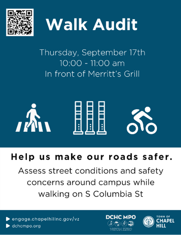
    The Vision Zero team invites you to step out with us for a Walk Audit along S Columbia St on Thursday, September 17, from 10:00 AM to 11:00 AM.

    A walk audit is a hands-on way for neighbors, advocates, and staff to review street conditions together. We’ll experience the corridor on foot, pinpoint specific safety issues, and collaborate on real-world improvements for people walking, biking, and rolling.

    📍 Event at a Glance

    • Who: Anyone passionate about pedestrian safety, Vision Zero, and creating calmer, safer community streets.

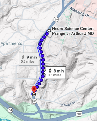
    • What: A 1-mile guided walk audit along S Columbia St from Merritt’s Grill to Mason Farm Rd.

    • When: Thursday, September 17 | 10:00 AM – 11:00 AM

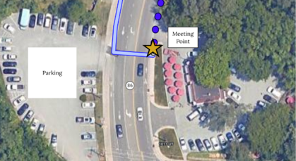
    • Where: Meeting on the sidewalk in front of Merritt’s Grill
    🚌 Getting There & Parking

    We encourage walking, biking, or transit to the site if possible!

    • Bus Stops: Just steps away from S Columbia at Purefoy Rd (Northbound & Southbound).

    • Parking: Available nearby at the Merritt’s Grill (1009 S Columbia St, Chapel Hill, NC 27514).

    👀 What to Expect On the Walk

    • No experience necessary! We will provide safety vests, worksheets, clipboards, and pens. You just bring your insights and a comfortable pair of walking shoes.

    • The Route: We’ll cover about 1 mile of total walking round-trip:
    • Prep Work (Optional but helpful): Take a quick virtual stroll through the corridor using Google Street View beforehand to note any spots you already know need love!

    📢 How You Can Help Right Now

    1. Spread the Word: Want a safer neighborhood? Invite your friends! Share this post or use to pass this info along to your neighborhood listservs, Nextdoor, or group chats.

    Want to make our streets safer and more accessible for everyone? Your boots-on-the-ground perspective is exactly what we need.

    The Vision Zero team invites you to step out with us for a Walk Audit along S Columbia St on Thursday, September 17, from 10:00 AM to 11:00 AM.

    A walk audit is a hands-on way for neighbors, advocates, and staff to review street conditions together. We’ll experience the corridor on foot, pinpoint specific safety issues, and collaborate on real-world improvements for people walking, biking, and rolling.

    📍 Event at a Glance

    • Who: Anyone passionate about pedestrian safety, Vision Zero, and creating calmer, safer community streets.

    • What: A 1-mile guided walk audit along S Columbia St from Merritt’s Grill to Mason Farm Rd.

    • When: Thursday, September 17 | 10:00 AM – 11:00 AM

    • Where: Meeting on the sidewalk in front of Merritt’s Grill

    🚌 Getting There & Parking

    We encourage walking, biking, or transit to the site if possible!

    • Bus Stops: Just steps away from S Columbia at Purefoy Rd (Northbound & Southbound).

    • Parking: Available nearby at the Merritt’s Grill (1009 S Columbia St, Chapel Hill, NC 27514).

    👀 What to Expect On the Walk

    • No experience necessary! We will provide safety vests, worksheets, clipboards, and pens. You just bring your insights and a comfortable pair of walking shoes.

    • The Route: We’ll cover about 1 mile of total walking round-trip:

    • Prep Work (Optional but helpful): Take a quick virtual stroll through the corridor using Google Street View beforehand to note any spots you already know need love!

    📢 How You Can Help Right Now

    1. Spread the Word: Want a safer neighborhood? Invite your friends! Share this post or use to pass this info along to your neighborhood listservs, Nextdoor, or group chats.

  • Request for Traffic Calming Evaluations Update

    Share Request for Traffic Calming Evaluations Update on Facebook Share Request for Traffic Calming Evaluations Update on X (formerly Twitter) Share Request for Traffic Calming Evaluations Update on Linkedin Email Request for Traffic Calming Evaluations Update link

    To evaluate a street for traffic calming, we use discrete sensors that track the number and speeds of vehicles over a typical one-week period. This information helps us make data-driven decisions about roadway safety improvements.

    Despite our efforts to repair the devices, the sensor units we use for traffic calming evaluations have been out of service. We worked internally across departments as well as directly with the supplier to troubleshoot the technology to determine the appropriate next steps. We ultimately decided to purchase new units, and we’re waiting for them to ship. Once we have shipping information, we’ll have a better idea of our timeline moving forward.

    With the new units, we will be able to determine whether the requested locations qualify for traffic calming interventions. We appreciate your patience as we work through your requests.

    To evaluate a street for traffic calming, we use discrete sensors that track the number and speeds of vehicles over a typical one-week period. This information helps us make data-driven decisions about roadway safety improvements.

    Despite our efforts to repair the devices, the sensor units we use for traffic calming evaluations have been out of service. We worked internally across departments as well as directly with the supplier to troubleshoot the technology to determine the appropriate next steps. We ultimately decided to purchase new units, and we’re waiting for them to ship. Once we have shipping information, we’ll have a better idea of our timeline moving forward.

    With the new units, we will be able to determine whether the requested locations qualify for traffic calming interventions. We appreciate your patience as we work through your requests.

  • Your Safe, Reliable Ride Around Town

    Share Your Safe, Reliable Ride Around Town on Facebook Share Your Safe, Reliable Ride Around Town on X (formerly Twitter) Share Your Safe, Reliable Ride Around Town on Linkedin Email Your Safe, Reliable Ride Around Town link

    As travel patterns shift with the start of the school year, this week is a great opportunity to explore Chapel Hill Transit as a safe and reliable way to get around town.

    With UNC students settling into their first week of classes and K–12 students returning next week, traffic is increasing across Chapel Hill and Carrboro. If you’re looking for a convenient, stress‑free way to move through town during this busy season, Chapel Hill Transit is one of the easiest options to try for the first time.

    Real‑Time Confidence with the Transit App
    If you’re new to riding transit, the Transit App lets you see real‑time bus locations, accurate arrival predictions, and step‑by‑step directions. It takes the uncertainty out of waiting at a stop and helps you plan trips confidently.
    Download the Transit App:
    Apple App Store
    Google Play

    Simple for First‑Time Riders
    Chapel Hill Transit is completely fare‑free, so there’s nothing to purchase or activate. Routes and schedules are straightforward, stops are close to UNC buildings, schools, neighborhoods, and major destinations, and service is easy to pick up even if you’ve never ridden before.

    Safe and Comfortable Travel
    With professional operators, maintained vehicles, and predictable routes, transit is one of the safest ways to move around town. Fewer cars on the road helps create calmer, more predictable streets, supporting our Vision Zero commitment to a community where everyone can travel safely

    Looking Ahead: North‑South Bus Rapid Transit (NS RAPID)
    The NS RAPID project will make riding even more convenient by improving travel times and reliability along one of Chapel Hill’s busiest travel corridors. You can learn more and share your input here:
    https://engage.chapelhillnc.gov/nsbrt

    As our community settles into school‑year routines, consider giving Chapel Hill Transit a try — even just once this week. With real‑time tracking, fare‑free service, and easy‑to‑use tools, it’s one of the safest and most convenient ways to get around town.

    As travel patterns shift with the start of the school year, this week is a great opportunity to explore Chapel Hill Transit as a safe and reliable way to get around town.

    With UNC students settling into their first week of classes and K–12 students returning next week, traffic is increasing across Chapel Hill and Carrboro. If you’re looking for a convenient, stress‑free way to move through town during this busy season, Chapel Hill Transit is one of the easiest options to try for the first time.

    Real‑Time Confidence with the Transit App
    If you’re new to riding transit, the Transit App lets you see real‑time bus locations, accurate arrival predictions, and step‑by‑step directions. It takes the uncertainty out of waiting at a stop and helps you plan trips confidently.
    Download the Transit App:
    Apple App Store
    Google Play

    Simple for First‑Time Riders
    Chapel Hill Transit is completely fare‑free, so there’s nothing to purchase or activate. Routes and schedules are straightforward, stops are close to UNC buildings, schools, neighborhoods, and major destinations, and service is easy to pick up even if you’ve never ridden before.

    Safe and Comfortable Travel
    With professional operators, maintained vehicles, and predictable routes, transit is one of the safest ways to move around town. Fewer cars on the road helps create calmer, more predictable streets, supporting our Vision Zero commitment to a community where everyone can travel safely

    Looking Ahead: North‑South Bus Rapid Transit (NS RAPID)
    The NS RAPID project will make riding even more convenient by improving travel times and reliability along one of Chapel Hill’s busiest travel corridors. You can learn more and share your input here:
    https://engage.chapelhillnc.gov/nsbrt

    As our community settles into school‑year routines, consider giving Chapel Hill Transit a try — even just once this week. With real‑time tracking, fare‑free service, and easy‑to‑use tools, it’s one of the safest and most convenient ways to get around town.

  • Eight Places You’ll Notice Safety Upgrades This Month

    Share Eight Places You’ll Notice Safety Upgrades This Month on Facebook Share Eight Places You’ll Notice Safety Upgrades This Month on X (formerly Twitter) Share Eight Places You’ll Notice Safety Upgrades This Month on Linkedin Email Eight Places You’ll Notice Safety Upgrades This Month link

    Town staff installed eight new Quick‑Build street safety projects—fast, flexible upgrades designed to slow speeds, improve visibility, and reduce crash risks. These locations were chosen using crash data and walk‑audits, combining what police reports tell us with details only visible when you stand in the street.

    These improvements follow the Safe Systems Approach, which recognizes that people make mistakes—but streets should be designed so those mistakes don’t turn into life‑changing injuries.


    Where We Made Improvements

    Quick‑Build safety upgrades now span key locations across Chapel Hill:

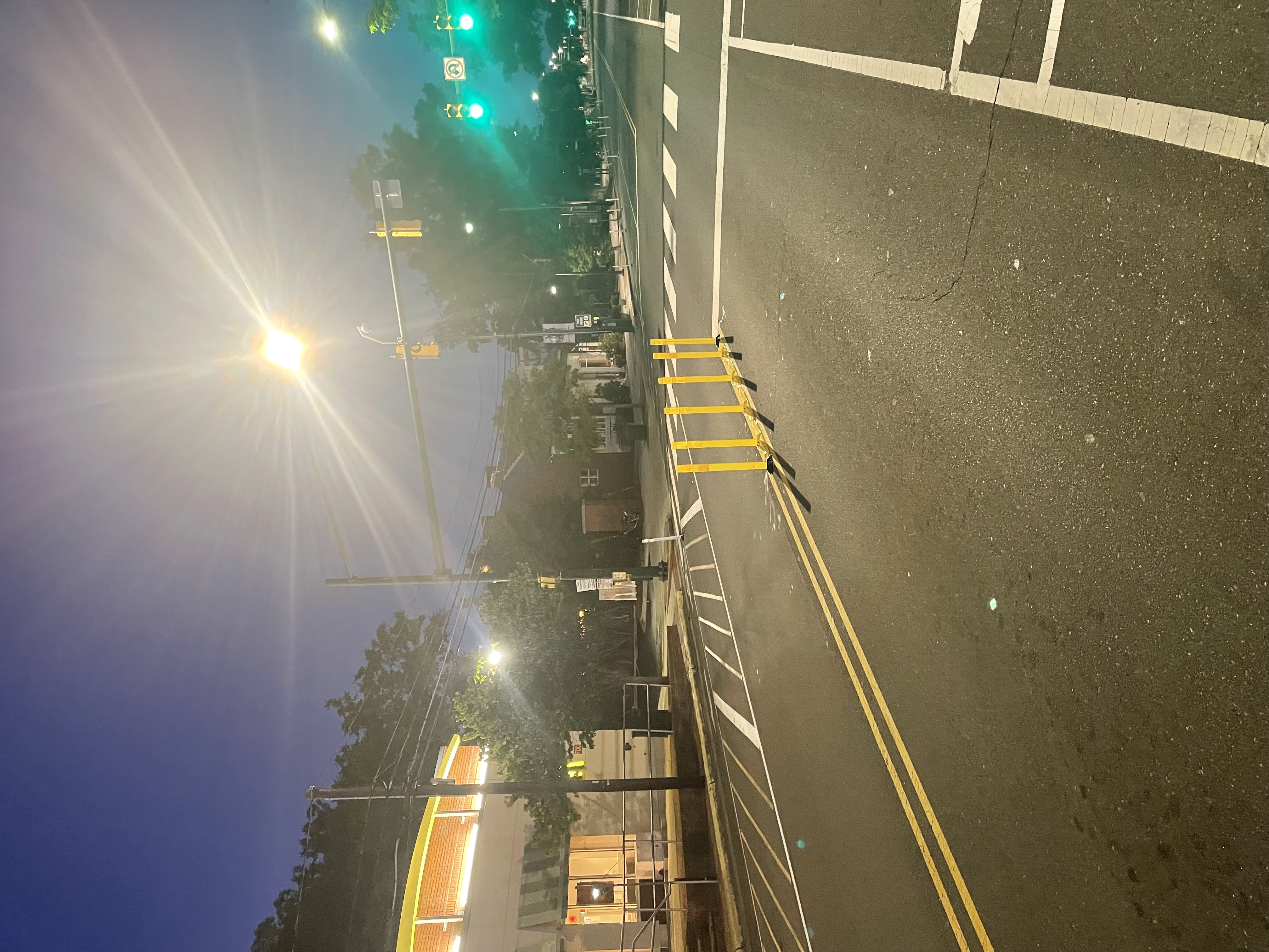
    West Franklin @ McDonald’s – centerline hardening to slow fast ,weeping left turns
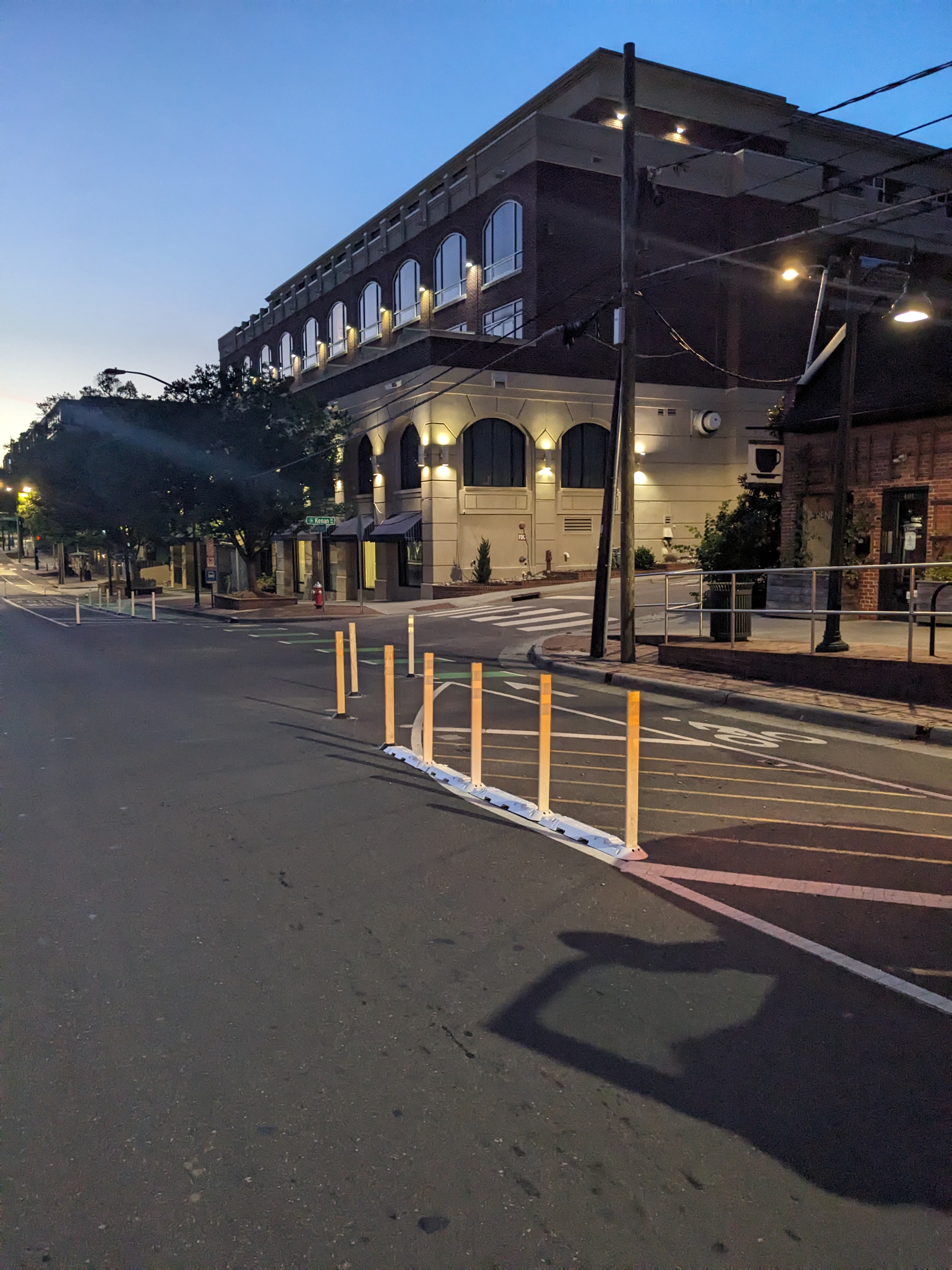
    Kenan & Mallette – daylighting corners and tightening turn radii to reduce right‑hook crashes
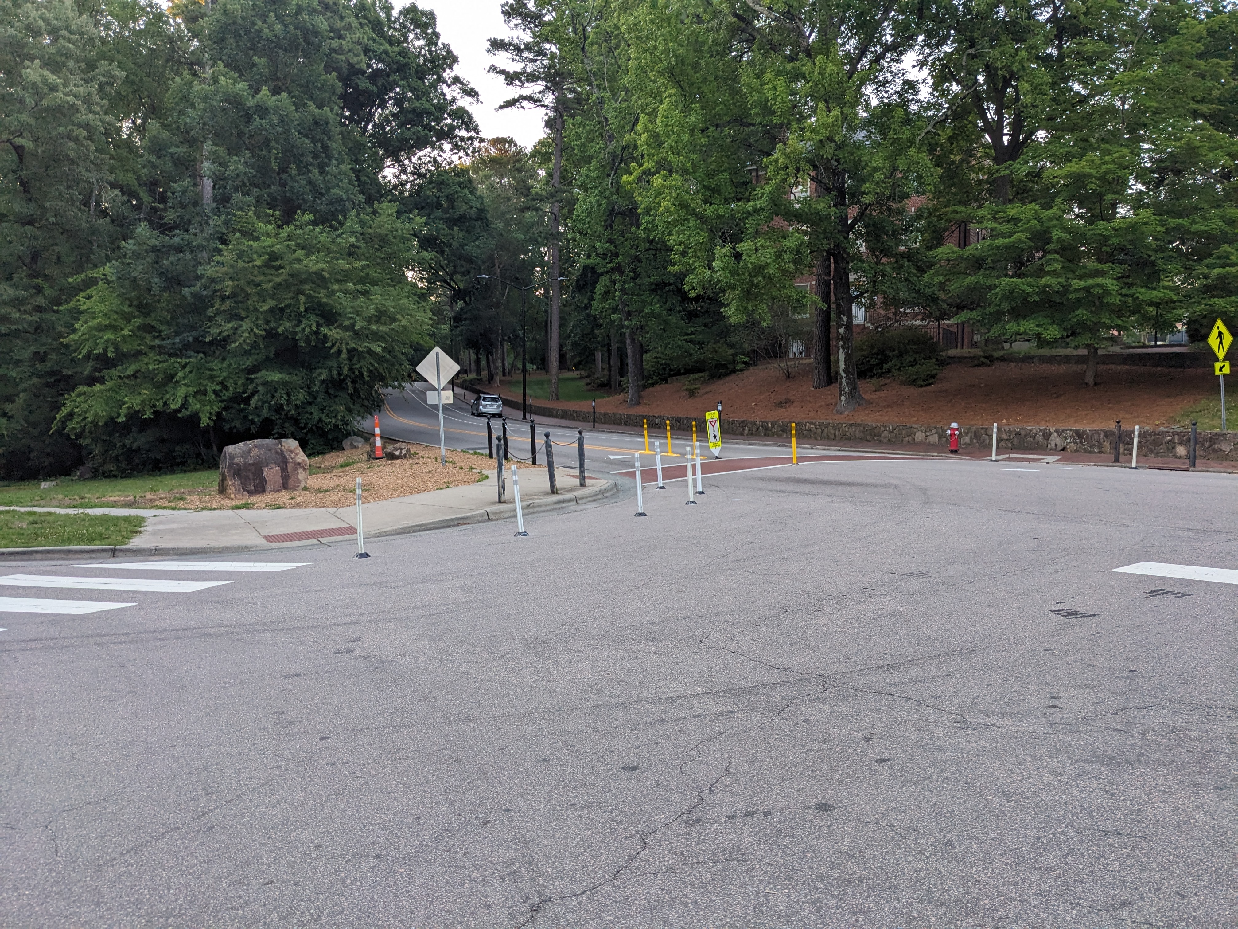
    Country Club Road – new gateway treatments and a bulb‑out to slow speeds
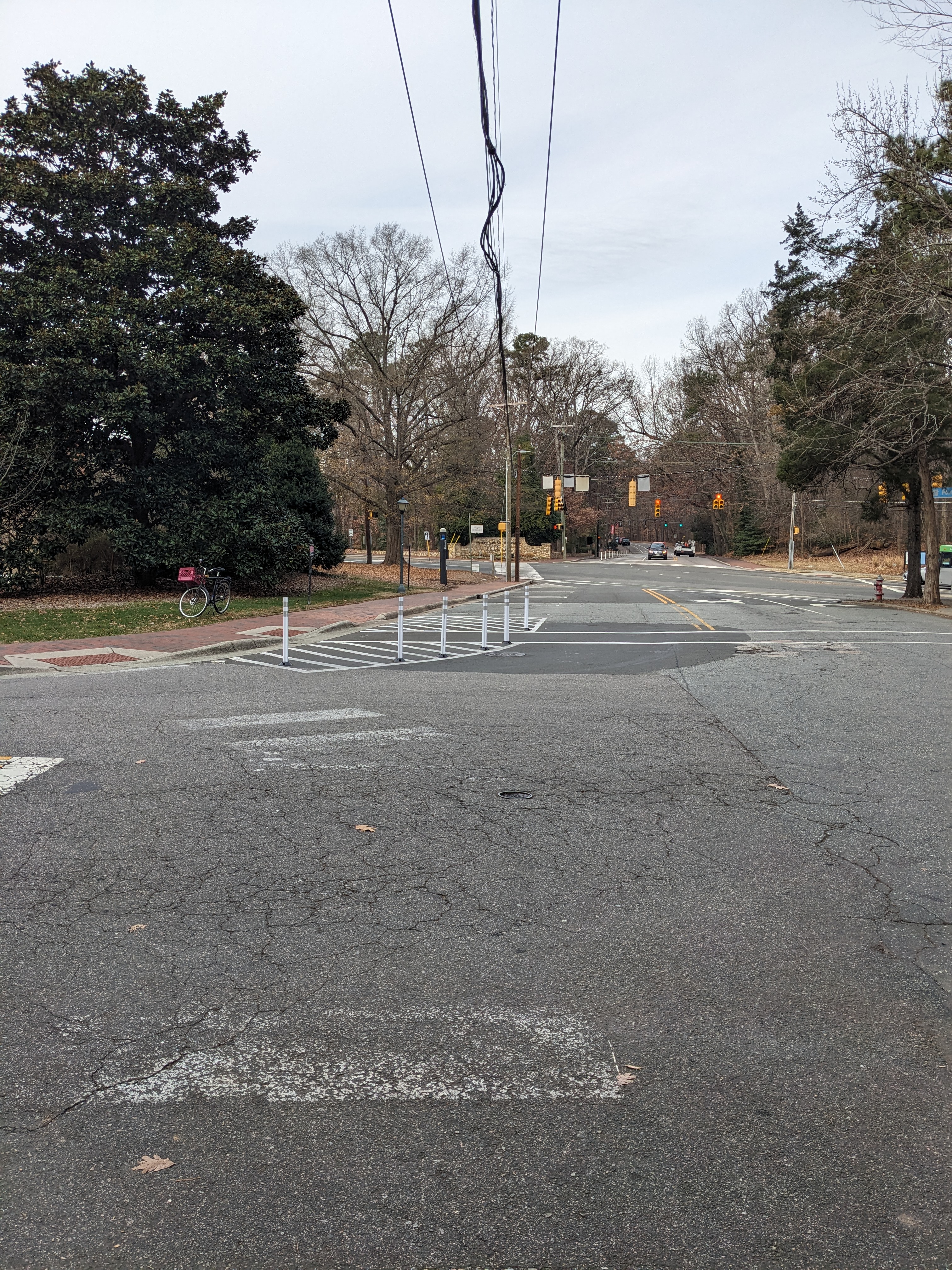
    Ridge @ Country Club – a shorter, clearer crossing for a major campus walking route
    Seawell School Road – gateway treatment responding to a dusk visibility‑related crash

    East Franklin Street – mid‑block gateway treatments on a high‑speed corridor
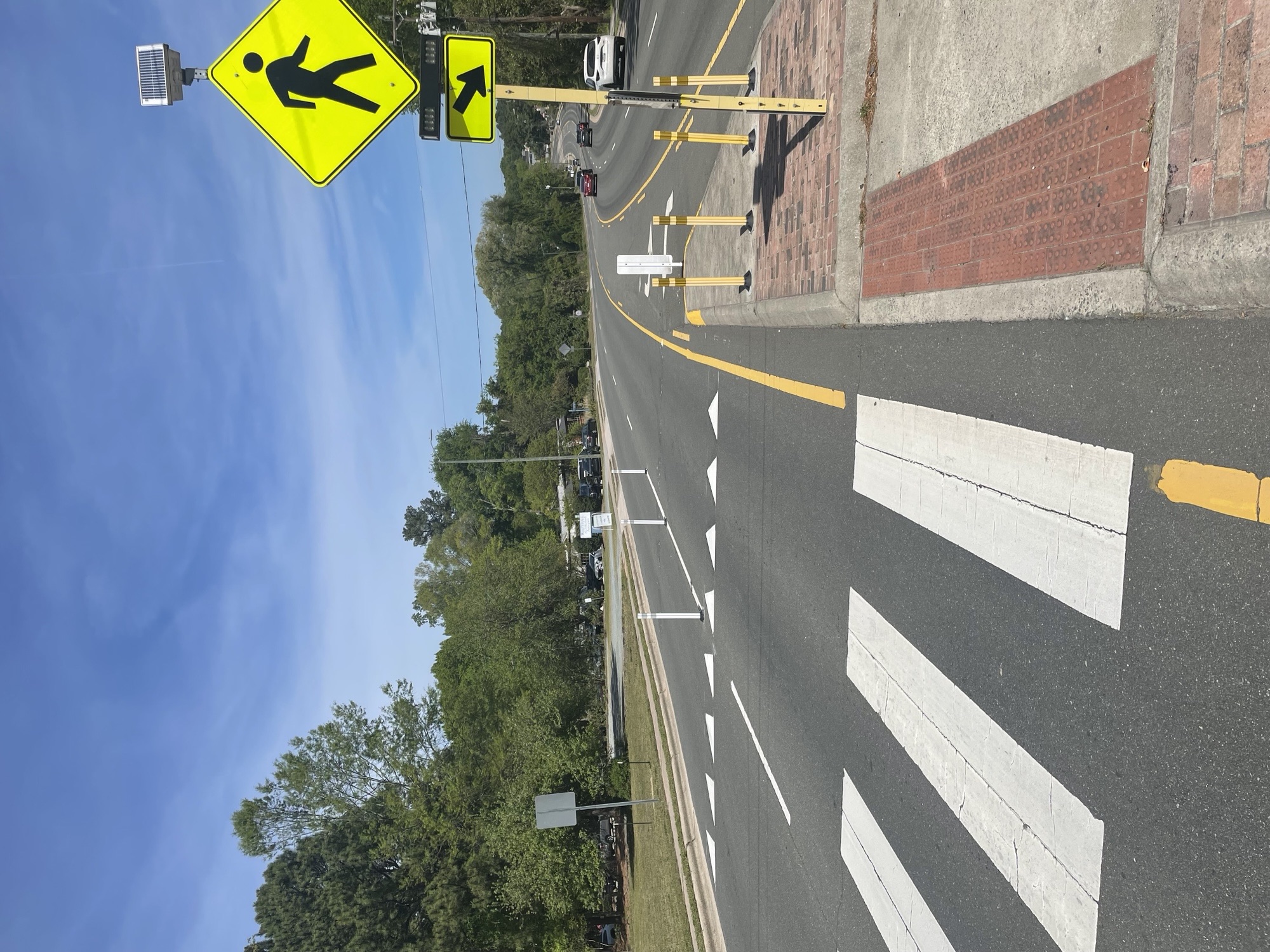
    Elliott Road – medians installed to calm traffic speeds


    Why These Projects Matter

    Quick‑Build projects help us:
    • slow drivers down where speed has been a factor
    • improve sight lines with daylighting and clearer markings
    • shorten crossing distances for people walking and biking
    • reduce turning conflicts at busy intersections
    • act quickly while larger capital projects are still years away
    • test designs before making long‑term changes


    How This Supports the Safe Systems Approach

    Your feedback and field observations shape these projects, but the approach is based on national best practices:

    Safe Speeds
    Narrowing lanes, tightening turns, and using gateway treatments help slow vehicles naturally.

    Safe Roads
    Clearer crosswalks, daylighting, mini‑medians, and centerline hardening reduce conflict points.

    Safe People
    Predictable designs help drivers, pedestrians, and cyclists understand how to navigate safely.

    Proven designs like centerline hardening and daylighting can reduce conflicts by up to 45 percent, and we’ll continue monitoring when students return in the Fall to make sure they're working.

    Learn more about the Safe Systems Approach → What Is a Safe System Approach? (U.S. DOT)


    What This Means for You

    With these upgrades in place, residents will notice:
    • safer, more visible crossings
    • slower turning speeds
    • clearer lane guidance
    • reduced mid‑block conflicts
    • more consistent vehicle speeds across several corridors


    What You Can Do Next

    Help us continue improving safety across Chapel Hill by sharing places where you’ve experienced near misses, uncomfortable crossings, or risky driving behaviors.

    Add your pin to the Close Calls Map:
    https://engage.chapelhillnc.gov/close-calls

    Your comments help us identify future Quick‑Build locations and supports our Safe Systems Approach by capturing things that don’t show up in crash data.

    Town staff installed eight new Quick‑Build street safety projects—fast, flexible upgrades designed to slow speeds, improve visibility, and reduce crash risks. These locations were chosen using crash data and walk‑audits, combining what police reports tell us with details only visible when you stand in the street.

    These improvements follow the Safe Systems Approach, which recognizes that people make mistakes—but streets should be designed so those mistakes don’t turn into life‑changing injuries.


    Where We Made Improvements

    Quick‑Build safety upgrades now span key locations across Chapel Hill:

    West Franklin @ McDonald’s – centerline hardening to slow fast ,weeping left turns

    Kenan & Mallette – daylighting corners and tightening turn radii to reduce right‑hook crashes

    Country Club Road – new gateway treatments and a bulb‑out to slow speeds

    Ridge @ Country Club – a shorter, clearer crossing for a major campus walking route

    Seawell School Road – gateway treatment responding to a dusk visibility‑related crash

    East Franklin Street – mid‑block gateway treatments on a high‑speed corridor

    Elliott Road – medians installed to calm traffic speeds


    Why These Projects Matter

    Quick‑Build projects help us:
    • slow drivers down where speed has been a factor
    • improve sight lines with daylighting and clearer markings
    • shorten crossing distances for people walking and biking
    • reduce turning conflicts at busy intersections
    • act quickly while larger capital projects are still years away
    • test designs before making long‑term changes


    How This Supports the Safe Systems Approach

    Your feedback and field observations shape these projects, but the approach is based on national best practices:

    Safe Speeds
    Narrowing lanes, tightening turns, and using gateway treatments help slow vehicles naturally.

    Safe Roads
    Clearer crosswalks, daylighting, mini‑medians, and centerline hardening reduce conflict points.

    Safe People
    Predictable designs help drivers, pedestrians, and cyclists understand how to navigate safely.

    Proven designs like centerline hardening and daylighting can reduce conflicts by up to 45 percent, and we’ll continue monitoring when students return in the Fall to make sure they're working.

    Learn more about the Safe Systems Approach → What Is a Safe System Approach? (U.S. DOT)


    What This Means for You

    With these upgrades in place, residents will notice:
    • safer, more visible crossings
    • slower turning speeds
    • clearer lane guidance
    • reduced mid‑block conflicts
    • more consistent vehicle speeds across several corridors


    What You Can Do Next

    Help us continue improving safety across Chapel Hill by sharing places where you’ve experienced near misses, uncomfortable crossings, or risky driving behaviors.

    Add your pin to the Close Calls Map:
    https://engage.chapelhillnc.gov/close-calls

    Your comments help us identify future Quick‑Build locations and supports our Safe Systems Approach by capturing things that don’t show up in crash data.

  • Help Us Spot Safety Concerns: Homestead Rd Walk Audit (June 10)

    Share Help Us Spot Safety Concerns: Homestead Rd Walk Audit (June 10) on Facebook Share Help Us Spot Safety Concerns: Homestead Rd Walk Audit (June 10) on X (formerly Twitter) Share Help Us Spot Safety Concerns: Homestead Rd Walk Audit (June 10) on Linkedin Email Help Us Spot Safety Concerns: Homestead Rd Walk Audit (June 10) link
    supporting image

    Want to make our streets safer and more accessible for everyone? Your boots-on-the-ground perspective is exactly what we need.

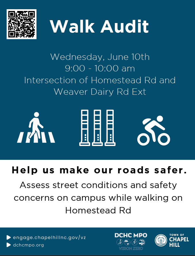
    The Vision Zero team invites you to step out with us for a Walk Audit along Homestead Road on Wednesday, June 10, from 9:00 AM to 10:00 AM.

    A walk audit is a hands-on way for neighbors, advocates, and staff to review street conditions together. We’ll experience the corridor as pedestrians, pinpoint specific safety issues, and collaborate on real-world improvements for people walking, biking, and rolling.

    📍 Event at a Glance

    • Who: Anyone passionate about pedestrian safety, Vision Zero, and creating calmer, safer community streets.

    • What: A 1-mile guided walk audit along Homestead Road to Seawell School Road.

    • When: Wednesday, June 10 | 9:00 AM – 10:00 AM

    • Where: Meeting at the intersection of Homestead Rd and Weaver Dairy Rd Ext.

    🚌 Getting There & Parking

    We encourage walking, biking, or transit to the site if possible!

    • Bus Stops: Just steps away at Homestead Road at Seymour Center (Northbound & Southbound via the HS Route).

    • Parking: Available nearby at the Seymour Center (2551 Homestead Rd #6, Chapel Hill, NC 27516).

    👀 What to Expect On the Walk

    • No experience necessary! We will provide safety vests, worksheets, clipboards, and pens. You just bring your insights and a comfortable pair of walking shoes.

    • The Route: We’ll cover about 1 mile of total walking (see the map attached below).

    • Prep Work (Optional but helpful): Take a quick virtual stroll through the corridor using [Google Street View] beforehand to note any spots you already know need love!

    📢 How You Can Help Right Now

    1. Spread the Word: Want a safer neighborhood? Invite your friends! Share this post or use to pass this info along to your neighborhood listservs, Nextdoor, or group chats.


    Want to make our streets safer and more accessible for everyone? Your boots-on-the-ground perspective is exactly what we need.

    The Vision Zero team invites you to step out with us for a Walk Audit along Homestead Road on Wednesday, June 10, from 9:00 AM to 10:00 AM.

    A walk audit is a hands-on way for neighbors, advocates, and staff to review street conditions together. We’ll experience the corridor as pedestrians, pinpoint specific safety issues, and collaborate on real-world improvements for people walking, biking, and rolling.

    📍 Event at a Glance

    • Who: Anyone passionate about pedestrian safety, Vision Zero, and creating calmer, safer community streets.

    • What: A 1-mile guided walk audit along Homestead Road to Seawell School Road.

    • When: Wednesday, June 10 | 9:00 AM – 10:00 AM

    • Where: Meeting at the intersection of Homestead Rd and Weaver Dairy Rd Ext.

    🚌 Getting There & Parking

    We encourage walking, biking, or transit to the site if possible!

    • Bus Stops: Just steps away at Homestead Road at Seymour Center (Northbound & Southbound via the HS Route).

    • Parking: Available nearby at the Seymour Center (2551 Homestead Rd #6, Chapel Hill, NC 27516).

    👀 What to Expect On the Walk

    • No experience necessary! We will provide safety vests, worksheets, clipboards, and pens. You just bring your insights and a comfortable pair of walking shoes.

    • The Route: We’ll cover about 1 mile of total walking (see the map attached below).

    • Prep Work (Optional but helpful): Take a quick virtual stroll through the corridor using [Google Street View] beforehand to note any spots you already know need love!

    📢 How You Can Help Right Now

    1. Spread the Word: Want a safer neighborhood? Invite your friends! Share this post or use to pass this info along to your neighborhood listservs, Nextdoor, or group chats.


  • Choosing Smarter Ways to Get Around (and Celebrating Bike Month!)

    Share Choosing Smarter Ways to Get Around (and Celebrating Bike Month!) on Facebook Share Choosing Smarter Ways to Get Around (and Celebrating Bike Month!) on X (formerly Twitter) Share Choosing Smarter Ways to Get Around (and Celebrating Bike Month!) on Linkedin Email Choosing Smarter Ways to Get Around (and Celebrating Bike Month!) link

    With gas prices higher this month, people across the country are rethinking how they commute. In Chapel Hill, it’s a perfect opportunity to explore travel options that save money, reduce stress, and make everyday trips more enjoyable.

    Comparing Costs: Driving vs. Transit & Biking

    Driving

    • Car payment: The average monthly payment for a new car is around $760, and about $537 for a used car.
    • Insurance: Full-coverage insurance averages roughly $180–200 per month
    • Gas: Households typically spend about $200 per month on fuel, often more when prices rise.
      Together, a commuter could easily spend over $1,000 each month to keep a car on the road.

    Transit
    Chapel Hill Transit is fare‑free—saving hundreds each month compared to the cost of driving.

    Biking
    Most destinations in Chapel Hill are within a bikeable distance, and our expanding network of bike lanes and greenways makes biking a comfortable, low‑cost option.

    The Town’s Commitment to More Non‑Car Travel Options
    The Town is actively working to expand safe, reliable, and convenient ways to get around without needing a car. This includes new and improved bike lanes, greenway connections, pedestrian safety upgrades, and enhanced mobility options across the community. These investments are part of our long‑term effort to make Chapel Hill easier to navigate for everyone—whether you walk, roll, bike, or ride transit.

    Celebrate Bike Month: Join Us at RollFest This Saturday
    RollFest 2026: The Wheel‑y Wild West

    • Date & Time: Saturday, May 16, 2026 • 10:00 AM–1:00 PM
    • Location: Chapel Hill Community Center, 120 S. Estes Drive
    • What to Expect:
      • Bike, skateboard, and scooter fun
      • Skill‑building and safety demos
      • Food truck
      • Information on local greenways, bike lanes, and mobility resources
      • Activities for all ages

    RollFest is our annual Bike Month celebration—an opportunity to explore active transportation, learn something new, and meet others interested in rolling around town.

    Explore Your Commuter Solutions
    Considering transit, biking, walking, carpooling, or mixing travel modes? Learn more here:
    https://www.chapelhillnc.gov/Transportation-and-Parking/Transportation-and-Mobility-Projects/Commuter-Solutions

    Let us know what changes you’re considering or what support would help make your commute easier.

    With gas prices higher this month, people across the country are rethinking how they commute. In Chapel Hill, it’s a perfect opportunity to explore travel options that save money, reduce stress, and make everyday trips more enjoyable.

    Comparing Costs: Driving vs. Transit & Biking

    Driving

    • Car payment: The average monthly payment for a new car is around $760, and about $537 for a used car.
    • Insurance: Full-coverage insurance averages roughly $180–200 per month
    • Gas: Households typically spend about $200 per month on fuel, often more when prices rise.
      Together, a commuter could easily spend over $1,000 each month to keep a car on the road.

    Transit
    Chapel Hill Transit is fare‑free—saving hundreds each month compared to the cost of driving.

    Biking
    Most destinations in Chapel Hill are within a bikeable distance, and our expanding network of bike lanes and greenways makes biking a comfortable, low‑cost option.

    The Town’s Commitment to More Non‑Car Travel Options
    The Town is actively working to expand safe, reliable, and convenient ways to get around without needing a car. This includes new and improved bike lanes, greenway connections, pedestrian safety upgrades, and enhanced mobility options across the community. These investments are part of our long‑term effort to make Chapel Hill easier to navigate for everyone—whether you walk, roll, bike, or ride transit.

    Celebrate Bike Month: Join Us at RollFest This Saturday
    RollFest 2026: The Wheel‑y Wild West

    • Date & Time: Saturday, May 16, 2026 • 10:00 AM–1:00 PM
    • Location: Chapel Hill Community Center, 120 S. Estes Drive
    • What to Expect:
      • Bike, skateboard, and scooter fun
      • Skill‑building and safety demos
      • Food truck
      • Information on local greenways, bike lanes, and mobility resources
      • Activities for all ages

    RollFest is our annual Bike Month celebration—an opportunity to explore active transportation, learn something new, and meet others interested in rolling around town.

    Explore Your Commuter Solutions
    Considering transit, biking, walking, carpooling, or mixing travel modes? Learn more here:
    https://www.chapelhillnc.gov/Transportation-and-Parking/Transportation-and-Mobility-Projects/Commuter-Solutions

    Let us know what changes you’re considering or what support would help make your commute easier.

  • May is Bike Month!

    Share May is Bike Month! on Facebook Share May is Bike Month! on X (formerly Twitter) Share May is Bike Month! on Linkedin Email May is Bike Month! link
    supporting image

    Celebrate all month long with community rides, family‑friendly events, and safety resources that support our Vision Zero commitment to safer streets for everyone. Explore events, learn safety tips, and help us build a more connected Chapel Hill. Scroll down to see what’s happening!

    May is National Bike Month, and Chapel Hill is excited to celebrate! It’s a chance to enjoy our community’s bike culture — from our bike lanes and greenways to our commitment to creating safer streets for everyone. As part of Vision Zero, Bike Month also highlights how we can all help prevent severe crashes and support people biking, walking, and rolling.

    Why Bike Month Matters
    Biking brings people together, boosts health, and helps reduce traffic and pollution. It also reminds us that:
    • Everyone deserves to move safely, no matter how they travel.
    • Drivers play a key role by slowing down, staying alert, and watching for people biking and walking.
    • Kids benefit when they have safe places to ride and build confidence.
    • Bike lanes and greenways make trips more comfortable and predictable for everyone.

    Bike Month Events
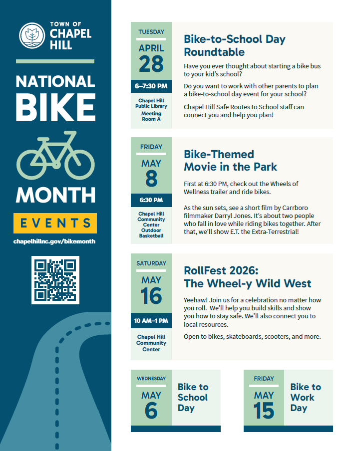
    Bike-to-School Day Roundtable – April 28, 6–7:30 p.m., Chapel Hill Public Library
    Council Proclamation – April 29, 6 p.m., Town Hall
    Bike to School Day – May 6, All Day, throughout Town
    Bike-Themed Movie in the Park – May 8, 6:30 p.m., Community Center
    Bike-to-Work Day – May 15, with a morning pit stop on Tanyard Branch Trail
    RollFest 2026: The Wheel-y Wild West – May 16, 10 a.m.–1 p.m., Community Center

    Safety Reminders
    • Slow down and watch for people biking, walking, and rolling — especially in neighborhoods and near schools.
    • Give people on bikes plenty of space.
    • Plan low‑stress trips on our greenway network.
    • Bikes can go on all Chapel Hill Transit buses (note: e‑bikes don't fit on racks).

    Learn More
    Explore resources and share feedback on our Vision Zero and Safe Routes to School Engage pages.

    Let’s celebrate Bike Month — and work together to build a safer, more connected Chapel Hill.

    Celebrate all month long with community rides, family‑friendly events, and safety resources that support our Vision Zero commitment to safer streets for everyone. Explore events, learn safety tips, and help us build a more connected Chapel Hill. Scroll down to see what’s happening!

    May is National Bike Month, and Chapel Hill is excited to celebrate! It’s a chance to enjoy our community’s bike culture — from our bike lanes and greenways to our commitment to creating safer streets for everyone. As part of Vision Zero, Bike Month also highlights how we can all help prevent severe crashes and support people biking, walking, and rolling.

    Why Bike Month Matters
    Biking brings people together, boosts health, and helps reduce traffic and pollution. It also reminds us that:
    • Everyone deserves to move safely, no matter how they travel.
    • Drivers play a key role by slowing down, staying alert, and watching for people biking and walking.
    • Kids benefit when they have safe places to ride and build confidence.
    • Bike lanes and greenways make trips more comfortable and predictable for everyone.

    Bike Month Events
    Bike-to-School Day Roundtable – April 28, 6–7:30 p.m., Chapel Hill Public Library
    Council Proclamation – April 29, 6 p.m., Town Hall
    Bike to School Day – May 6, All Day, throughout Town
    Bike-Themed Movie in the Park – May 8, 6:30 p.m., Community Center
    Bike-to-Work Day – May 15, with a morning pit stop on Tanyard Branch Trail
    RollFest 2026: The Wheel-y Wild West – May 16, 10 a.m.–1 p.m., Community Center

    Safety Reminders
    • Slow down and watch for people biking, walking, and rolling — especially in neighborhoods and near schools.
    • Give people on bikes plenty of space.
    • Plan low‑stress trips on our greenway network.
    • Bikes can go on all Chapel Hill Transit buses (note: e‑bikes don't fit on racks).

    Learn More
    Explore resources and share feedback on our Vision Zero and Safe Routes to School Engage pages.

    Let’s celebrate Bike Month — and work together to build a safer, more connected Chapel Hill.

  • S. Merritt Mill Road Walk Audit - 9am on 3/11

    Share S. Merritt Mill Road Walk Audit - 9am on 3/11 on Facebook Share S. Merritt Mill Road Walk Audit - 9am on 3/11 on X (formerly Twitter) Share S. Merritt Mill Road Walk Audit - 9am on 3/11 on Linkedin Email S. Merritt Mill Road Walk Audit - 9am on 3/11 link
    supporting image

    Who: Anyone interested in Vision Zero, pedestrian safety, and safer streets

    What: S Merritt Mill Walk Audit

    When: Wednesday March 11th from 9:00 AM-10:00 AM

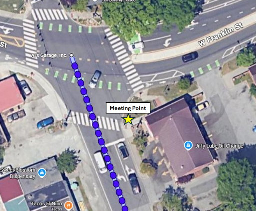
    Where: Merritt Mill Rd, in front of the Jiffy Lube building

    Why: We will assess current conditions, identify safety concerns, and develop potential improvements in this area.


    Getting there:

    Parking:

    • 505 W Franklin St, Chapel Hill, NC 27516
    • 103 Boyd St, Carrboro, NC 27510
    • 208 Sunset Dr, Chapel Hill, NC 27516

    Closest bus stops:

    • West Franklin Street at North Roberson Street (CW, F, J)


    What to expect:

    • If you have never done one, the purpose of a walk audit is to gather on-the-ground knowledge of safety concerns cyclists and pedestrians face so that we can find potential improvements.
    • We will have safety vests, worksheets, clipboards, and pens for all participants.
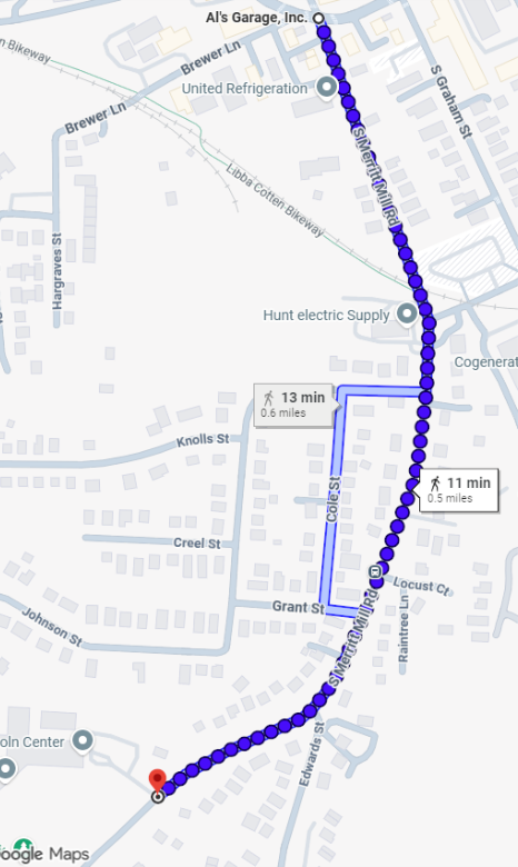
    • We expect the total distance covered will about 1 mile of total walking (see map attached).


    Please take a virtual walk in Google Street view prior to meeting.

    Who: Anyone interested in Vision Zero, pedestrian safety, and safer streets

    What: S Merritt Mill Walk Audit

    When: Wednesday March 11th from 9:00 AM-10:00 AM

    Where: Merritt Mill Rd, in front of the Jiffy Lube building

    Why: We will assess current conditions, identify safety concerns, and develop potential improvements in this area.


    Getting there:

    Parking:

    • 505 W Franklin St, Chapel Hill, NC 27516
    • 103 Boyd St, Carrboro, NC 27510
    • 208 Sunset Dr, Chapel Hill, NC 27516

    Closest bus stops:

    • West Franklin Street at North Roberson Street (CW, F, J)


    What to expect:

    • If you have never done one, the purpose of a walk audit is to gather on-the-ground knowledge of safety concerns cyclists and pedestrians face so that we can find potential improvements.
    • We will have safety vests, worksheets, clipboards, and pens for all participants.
    • We expect the total distance covered will about 1 mile of total walking (see map attached).


    Please take a virtual walk in Google Street view prior to meeting.

  • Skipper Bowles Drive Walk Audit 1/12/26

    Share Skipper Bowles Drive Walk Audit 1/12/26 on Facebook Share Skipper Bowles Drive Walk Audit 1/12/26 on X (formerly Twitter) Share Skipper Bowles Drive Walk Audit 1/12/26 on Linkedin Email Skipper Bowles Drive Walk Audit 1/12/26 link
    supporting image

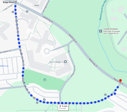
    The Vision Zero team invites you to join our walk audit on Monday January 12th from 9:00 AM-10:00 AM. The audit route will be around one mile, along Skipper Bowles Dr. Our central meeting location will be the Ridge Rd and Manning Dr intersection. A walk audit allows us to assess the conditions of the street, identify safety concerns, and develop potential improvement in this area.


    If you would like to send this email out to your neighbors and community members, please use this link! Thank you very much and we hope to see you there!

    Who: Anyone

    The Vision Zero team invites you to join our walk audit on Monday January 12th from 9:00 AM-10:00 AM. The audit route will be around one mile, along Skipper Bowles Dr. Our central meeting location will be the Ridge Rd and Manning Dr intersection. A walk audit allows us to assess the conditions of the street, identify safety concerns, and develop potential improvement in this area.


    If you would like to send this email out to your neighbors and community members, please use this link! Thank you very much and we hope to see you there!

    Who: Anyone interested in Vision Zero, pedestrian safety, and safer streets

    What: Skipper Bowles Walk Audit

    When: Monday January 12th from 9:00 AM-10:00 AM

    Where: Intersection of Ridge Rd and Manning Dr

    Why: We will assess current conditions, identify safety concerns, and develop potential improvements in this area.

    Getting there:

    • Parking:
    1. Williamson Lot (Paid Parking)
    2. Rams Head Parking Deck (Paid Parking)
    • Closest bus stops:
      1. Bowles Drive at Craige Dorm (RU)
      2. Manning Drive at Hinton James (U)
      3. Ridge Road at Ehringhaus Hall (CCX and RU)

    What to expect:

    • If you have never done one, the purpose of a walk audit is to gather on-the-ground knowledge of safety concerns cyclists and pedestrians face so that we can find potential improvements.
    • We will have safety vests, worksheets, clipboards, and pens for all participants.
    • We expect the total distance covered will about 1 mile of total walking (see map attached).

    Please take a virtual walk in Google Street view prior to meeting.


  • Legion Road Walk Audit 11/17

    Share Legion Road Walk Audit 11/17 on Facebook Share Legion Road Walk Audit 11/17 on X (formerly Twitter) Share Legion Road Walk Audit 11/17 on Linkedin Email Legion Road Walk Audit 11/17 link
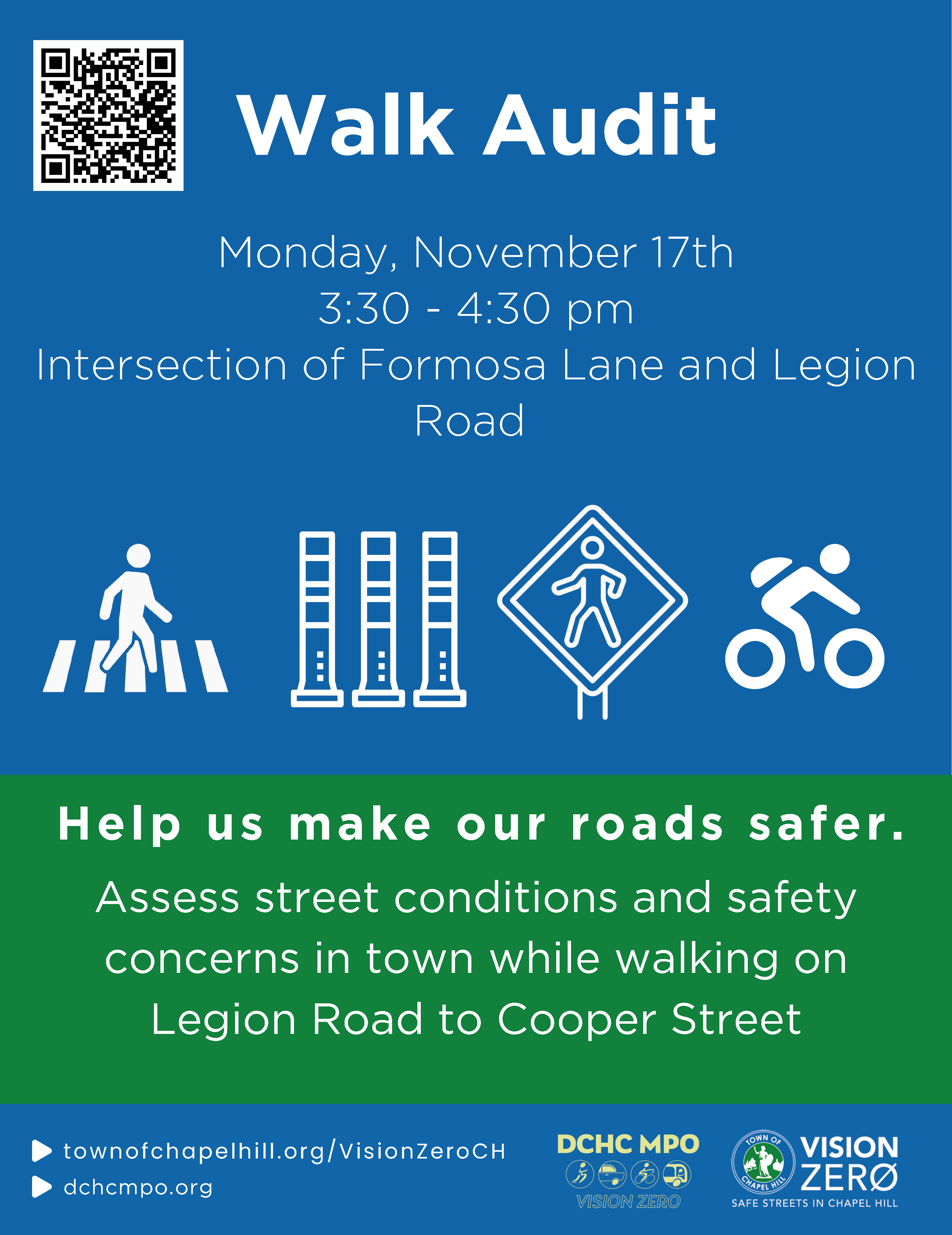
    The Vision Zero team invites you to join our walk audit on Monday November 17th from 3:30 PM-4:30 PM. The audit route will be around a mile from Formosa Lane to Cooper Street along Legion Rd. Our central meeting location will be the Formosa Ln. and Legion Rd. Intersection

    A walk audit allows us to assess the conditions of the street, identify safety concerns, and develop potential improvement in this area. If you would like to send this out to your neighbors and community members, please use this link! Thank you very much and I

    The Vision Zero team invites you to join our walk audit on Monday November 17th from 3:30 PM-4:30 PM. The audit route will be around a mile from Formosa Lane to Cooper Street along Legion Rd. Our central meeting location will be the Formosa Ln. and Legion Rd. Intersection

    A walk audit allows us to assess the conditions of the street, identify safety concerns, and develop potential improvement in this area. If you would like to send this out to your neighbors and community members, please use this link! Thank you very much and I hope to see you there!

    Who: Anyone interested in Vision Zero, pedestrian safety, and safer streets

    What: Legion Walk Audit

    When: Monday November 17th from 3:30 PM-4:30 PM

    Where: Intersection of Formosa Ln. and Legion Rd.

    Why: We will assess current conditions, identify safety concerns, and develop potential improvements in this area.

    Getting there:

    • Parking:

    • Village Office Park

    • Closest bus stops:

    • Legion Road at Formosa Drive (Bus Route D)

    What to expect:

    • If you have never done one, the purpose of a walk audit is to gather on-the-ground knowledge of safety concerns cyclists and pedestrians face so that we can find potential improvements.

    • We will have safety vests, worksheets, clipboards, and pens for all participants.

    • We expect the total distance covered will about 1 mile of total walking (see map attached).

    Please take a virtual walk in Google Street view prior to meeting.

Page last updated: 01 Sep 2026, 10:34 PM